

Calabarzon Mountain
“Every mountain top is within reach if you just keep climbing.”
-Barry Finlay

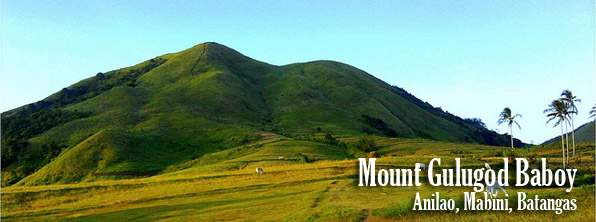
Destination: MT. Gulugod Baboy – Anilao, Mabini, Batangas
Jump-off point: Philpan Dive Resort, Anilao, Mabini
Days required / Hours to summit: Half-day / 1-2 hours
Nature of Climb: Minor climb, Difficulty 2/9, Trail class 1-2
Gulugod Baboy is literally translated into English as “Pig’s Spine,” it is located in the town of Mabini in the southern part of the province of Batangas. Its jump-off is located in Anilao (the birthplace of scuba diving in the Philippines) making a dip in the sea an extra bonus after a tiring day of hiking.
Although Gulugod Baboy has a short trail and would be fitting for a day-hike, it is also a good candidate for an overnight trip, the sunset and the sunrise are breath-taking.
ITINERARY (Day Hike)
0500 ETD Manila via bus bound to Batangas City
0730 ETA Batangas City, charter a jeep to Anilao
0800 ETA Brgy. San Teodoro or Philpan dive resort Anilao
0830 Start trek
1000 ETA Gulugod-Baboy (Peak 1)
1040 ETA Gitna (Peak 2)
1130 ETA Pinagbanderahan (Peak 3). Lunch
1200 Descent via Brgy. Laurel
1300 ETA Brgy. Laurel, Mabini. Take jeep to town proper
1330 ETA Mabini town proper; take jeep to Batangas City

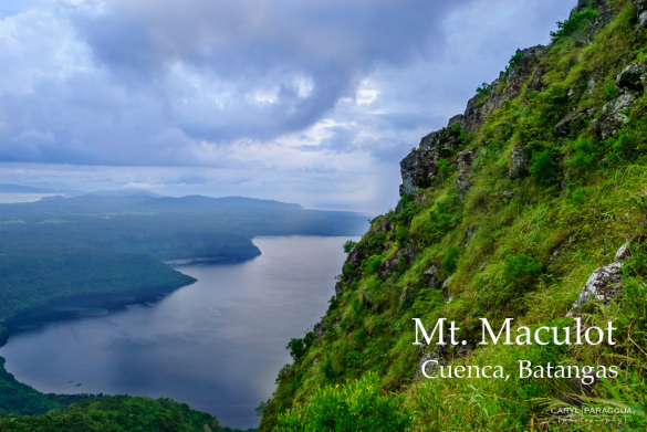
Destination: MT. MACULOT – Cuenca, Batangas
Jump-off point: Mountaineer’s Store, Brgy. 7 “Siete”, Cuenca
Days required / Hours to summit: 1 day / 2-4 hr
Nature of Climb: Minor climb, Difficulty 4/9, Trail class 1-3
Mount Maculot is a mountain located in the town of Cuenca in Batangas province. Mount Maculot’s summit stands at approximately 947 MASL, its high volcanic wall (popularly know as “The Rockies”) is at 703 MASL. Maculot is adjacent to Taal Lake and is said to be part of Taal Caldera’s crater rim. This mountain is popular among mountain climbers and climbers making it as the municipality’s major tourist attraction.
Although having three destinations: the famous Rockies (703m), the summit (947m) and the Grotto (510m), most climbers were contented on reaching the Rockies, this is the reason why Maculot became the paragon of an easy hike. The 3 destination can be covered by a traverse dayhike, once the campsite is reached, take the lefttrail towards the Rockies, this will take at least five minutes, then trek towards the summit, from the summit, descent towards the Grotto on the other side of the mountain, spending time for picture taking and rest on each stops, from the Grotto head back to the jump-off point. To maximize the Maculot adventure, plan a longer stay on the mountain, an overnight stay would make a big difference.
At the campsite, there is a big store dubbed as “7-11″, the store offers everything from hard drinks to halo-halo and is open on weekends and peak season days during Holy Week etc. The campsite can fit 20 or more tents, on a weekend, the camp may be full.
How to get there?
Take the bus bound to Lemery Batangas, bus terminals are located in Cubao or Buendia (Gil Puyat). The fare is around 150-170 pesos, it will take you an approximately 2.5 hours to reach Cuenca Poblacion (town proper), tell the bus conductor to drop you at Poblacion (Cuenca). The jump-off is near the Municipal hall, you must register at the Barangay Outpost (P10) and get their contact number for security purposes.
SUGGESTED ITINERARY TRAVERSE (Rockies-Summit-Grotto)
0500 Board Lemery-bound bus from Buendia or Cubao (~P130)
0800 ETA Cuenca Muncipal Hall. Walk or take trike to jump-off. Pay P10 registration fee.
0830 start trek
1000 arrive at campsite, head to Rockies
1010 at Rockies; take pictures
1110 Leave for the summit
1230 ETA Summit of Mt. Maculot. Lunch
1300 Start descent to Grotto
1430 Arrival at Grotto. Rest.
1445 Resume descent.
1600 Arrival at exit point

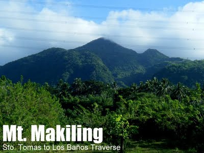
Destination: MT. MAKILING – Los Baños, Laguna
Jump-off point (via UP Los Baños/Traditional Trail): Station 1, UP College of Forestry
Days required / Hours to summit: 1-2 days / 4-5 hours
Nature of Climb: Minor climb, Difficulty 4/9, Trail class 1-3
Jump-off point (Mt. Makiling Traverse): Sitio Palanggana, Brgy. San Bartolome; Sitio Sipit, Brgy. San Miguel
Days required / Hours to summit: 1-2 days / 7-8 hours
Nature of Climb: Major climb, Difficulty 6/9, Trail class 3 with roped segments
Mount Makiling (locally known as Bundok ni Mariang Makiling) is a dormant volcano located in the town of Los Baños, Laguna.
It’s name is believed to come from a legendary local character “Maria Makiling,” the mountain’s guardian fairy. The contour of the mountain is said to be that of her in a reclining position.
The mountain was adopted by the University of the Philippines as a protected area, it has been one of the favorite destinations for mountaineers, scientist and tourists. The forest, which was restored during the 1910s, remains in pristine condition; a plethora of birds, reptiles, and other fauna continue to thrive in Makiling. The trail leading to peak 2 remains in pristine condition despite the damage created by typhoon ‘Milenyo.’
There are two existing trails, the UP Los Baños trail and the Makiling Traverse (MakTrav).
When using the UPLB trail, you might want to visit the Mudsprings (also known as the ‘crater’), here you could see pools of boiling mud. Another must see area is the Flatrocks, a river with slabs of flat rocks, this is located just near the jump-off.
The more challenging trail (MakTrav) has two jump-off points, first is the Palanggana trail jumping-off from Sitio Palanggana in Barangay San Bartolome and the Sipit trail from Sitio Sipit, Barangay San Miguel both are located in the town of Sto. Tomas, Batangas. It takes around seven hours from jump-off to Peak 2. It starts off with cogon fields until the forests become denser and denser. Landscapes include Haring Bato, the breathtaking Melkas ridge, and Peak 3, also known as Mt. Cornites. It then connects to Peak 2, allowing a traverse.
Suggested Itinerary via Los Baños (Traditional Trail):
0430 Assembly at LRT-Buendia, board Sta. Cruz bus
0630 ETA Los Baños Crossing, walk to corner beside Robinson’s Place for jeep to Forestry , or rent any passing jeep
0700 ETA jump-off point, College of Forestry, register
0730 Start trek
0845 ETA Nursery, you can buy drinks here.
0900 Head off to Peak 2. Take note of the stations to mark your progress.
1015 ETA last campsite.
1130 reach the so-called ’90 degrees’ at Stn. 27. Use the ropes.
1200 ETA Peak 2 (station 30), lunch
1300 Start descent
1600 ETA road to Nursery, proceed to Mudspring as a sidetrip.
1620 Arrive at Mudspring, take pictures.
1645 Back at Nursery, start walk back to jump-off
1800 Back at jump-off; walk down the road and wait for jeepney
1830 Dinner at Grove, Los Baños (many food options here)
1930 Head back to Los Baños Crossing, take Buendia or Cubao. (note: last trip for Buendia is 2030H)
Suggested Itinerary via Palanggana Trail (MakTrav):
0430 Take Lucena or any Maharlika-bound bus
0600 Drop off at Jolibee Sto. Tomas; Breakfast
0630 Head to Brgy. San Bartolome by tricycle
0700 Registration; final preparations
0730 Start trek
0830 ETA Bahay Kubo
1030 ETA Melkas Ridge campsite
1100 ETA Melkas Ridge (Haring Bato)
1130 Lunch at Peak 3 (1020 MASL)
1200 Proceed with traverse via Wild Boar trail
1330 ETA Peak 2 (1090 MASL)
1400 Start descent
1630 ETA Nursery
1730 ETA College of Forestry; take jeep to Los Banos proper
1800 Lunch at Grove
1900 Take bus back to Manila
2100 ETA Manila
Mount Makiling Updates
Maktrav (Makiling Traverse) Palanggana trail in Sition San Bartolome is closed to mountaineers for it passes a private property, alternatively, Sipit Trail is open for climbers located on Sitio Jordan Eco Park ( dumpsite ) in San Miguel.
How to get to MakTrav Sipit Trail
- Take any Lucena bound bus, take off at San Felix: Marker – Sea Oil;
- Trike to Sitio Kordan Eco Park
- Look for Danny Villegas – VP of Municipal Emergency Response Team

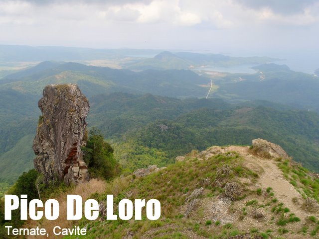
Destination: PICO DE LORO – Mount Palay-Palay National Park, Ternate, Cavite
Jump-off point: Magnetic Hill, Ternate, Cavite
Days required / Hours to summit: 1-2 days / 2-5 hours
Nature of Climb: Minor climb, Difficulty 3/9, Trail class 1-3
Pico de Loro is considered to be the highest point of the Province of Cavite, its peak is estimated to be at 664 MASL. It is also the highest point within the boundary of Cavite and Batangas provinces. The name Pico de Loro literally means “Parrot’s Peak,” during the Spanish inquisition, Spanish sailors aboard their galleons to Manila Bay noticed the form of a giant parrot in the forested mountains of Cavite, thus naming it as Pico de Loro.
On its summit, mountaineers can see Batangas and Bataan shore lines while the entire Batangas and Cavite on the south-eastern side will offer you a magnificent view of the south-eastern mountains like Batulao andTalamitam.
At least two waterfalls are located near the trails leading to Pico de Loro. One is past the Basecamp 1 (this is the more popular one) whereas the other is before it, near the Maragondon trail. They are best visited during the rainy season.
From the summit, you can opt to scale the Parrot’s Peak (or most commonly known as the “Tower”), this is considered to be the centerpiece of the views at the top. Scaling the “Tower” can be dangerous though, one must have rock climbing skills and experience, this climb includes a brief scramble which can be dangerous.
How to get to Pico de Loro?
From Manila, take a bus (Saulog Transit) bound to Ternate at Park and Ride terminal in Manila (near the LRT Line 1 Central Station), the travel will take at least 2-3 hours depending on the traffic situation. Upon arriving in Ternate, you can rent a jeepney to Magnetic Hill (jump-off point), pay the DENR registration fee and start the climb.
SUGGESTED ITINERARIES
DAYHIKE
0400 Board Saulog bus at Lawton to Ternate
0700 ETA Ternate. Rent jeepney to Magnetic Hill
0745 ETA DENR / jump-off point. (P20 registration)
0800 Start trek. Note that jump-off point is 5 minutes’ walk away from DENR.
0845 ETA rest station, Basecamp 1 (P20 registration)
1130 ETA summit. Lunch.
From this point, take either Option A (Backtrail) or B (Traverse)
Option A: Backtrail to Ternate
1230 start descent to Magnetic Hill
1530 ETA jump-off point.
1600 Back at DENR; take jeepney to Ternate then take bus back to Manila
1900 ETA Manila.
Option B: Traverse to Nasugbu
1230 start descent to Nasugbu-Ternate Highway
1530 ETA Nasugbu-Ternate Highway.
1700 Arrival in Nasugbu. Dinner. Bus terminal is near Jolibee.
2100 ETA Manila.
OVERNIGHT
DAY 1 : Pack Breakfast and Lunch
0400 Board Saulog bus at Lawton to Ternate (~P110)
0700 ETA Ternate. Rent jeepney to Magnetic Hill (P500/one-way)
0745 ETA DENR / jump-off point. (P20 registration)
0800 Start trek. Note that jump-off point is 5 minutes walk away from DENR.
0845 ETA rest station, Basecamp 1 (P20 registration)
1130 ETA Campsite. Lunch. Pitch tent
1400 Explore summit and rock tower
1600 Back to campsite
1700 Campsite prepare dinner
1830 Dinner
2000 Lights out
DAY 2
0600 Week-up call breakfast, break camp
0800 Start descent to water falls
1130 ETA water falls, lunch, swimming
1300 Resume trek to base camp
1400 ETA base camp
1415 Resume trek to DENR
1600 ETA DENR / wash up
1630 Take jeepney to Ternate
1700 Take bus back to Manila
2000 ETA Manila.

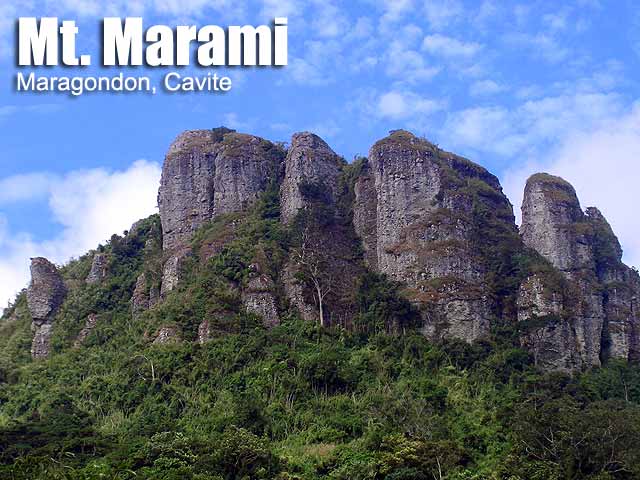
MT. MARAMI
Maragondon, Cavite
Jump-off point: Brgy. Ramirez, Magallanes, Cavite
LLA: 405 MASL
Days required / Hours to summit: 1-2 days / 4-6 hours
Specs: Minor climb, Difficulty 3/9, Trail class 1-3
BACKGROUND
If Pico de Loro were a blockbuster movie, its sequel would be Mt. Marami, set in the same location and sharing the same characteristics. Matching Pico de Loro's rocky tower are two grand structures, surging up from the slopes: the summit of Mt. Marami, a massive, monumental composite of rocky pillars; and its guardian, the smaller Silyang Bato. The name 'Marami' is of local origin, and is attributed to the 'many rocks' that formed it. Subconsciously, this choice of name is profound, considering the sedimentary nature of the rocks found in Marami. Indeed, in recent geologic past, Mt. Marami below sea level. Silyang Bato, for its part, has a more modern etymology; according to the locals its original name is 'Nagbuo', and was christened with its present name by the earlier mountaineers.
ITINERARY
VIA THE NUESTRA SENORA TRAIL
Day 1
0500 ETD Manila. Take Saulog bus to Naic (P65)
0700 ETA Naic; take jeep to Magallanes (P30)
0800 ETA Magallanes. Register at police station. Take tricycle to Brgy. Ramirez
0900 ETA Brgy. Ramirez, at Kon. Punongbayan's house. Register. (P20)
0930 Start trek
1000 ETA Ilog na Kayrayag
1100 Cross three segments of Bangkaan River; proceed to Nuestra Señora de la Paz
1200 Have lunch at Kapihan Nipa hut. There's a nearby water source.
1300 Resume trek to Campsite 1
1400 ETA Campsite 1
1500 Reach Bamboo Forest
1600 ETA campsite at base of Mt. Marami summit.
1630 Assault the summit; explore
1800 Return to camp.
1830 Dinner / socials
Day 2
0530 Wake up / sunrise viewing
0630 Breakfast
0730 Break camp
0800 Start descent
1030 Back at Kapihan nipa hut
1230 Back at jump-off point at Brgy. Ramirez
1300 Leave for Municipal Hall, then Naic via jeep
1400 ETA Naic. Take bus back to Manila
1700 Back in Manila.

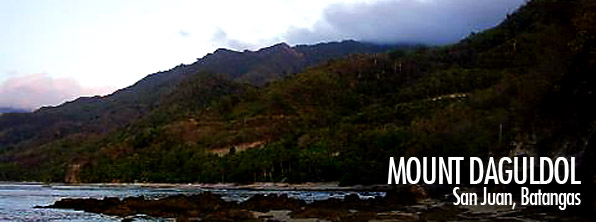
Destination: MT. DAGULDUL — San Juan, Batangas
Jump-off point: Brgy. Hugom, San Juan, Batangas
Days required / Hours to summit: 1-2 days / 5 hours
Nature of Climb: Minor climb, Difficulty 3/9, Trail class 1-3
Located in southern Batangas is the coastal mountain of San Juan, Mt. Daguldul. Mount Daguldul may have gotten it’s name by describing the grandeur of the range and the abrupt rolling of its slopes.
A good things about Mt. Daguldul is that the guides are organized under the Hugom Environmental Guides Association (HEGA). This means that fees are fixed and they are reasonsable – guides for P400/day and aclimbing fee of P30 (as of 2006). The trail starts off at the beach where you will be welcomed by majestic rock formation. Afterwards, you will enter the forest. There are 3 campsites near the summit, namely Campsite 1 (Gulugod-Baboy); Campsite 2 (Niyugan – lots of cocount trees); and Campsite 3 (Anahawan). Usually, the determining factor in camping is the one you reach before nightfall, but these campsites are all within the area which you can explore anyway.
The summit area is windy, as expected from a coastal mountain. Grasslands make for a ‘picnic ground’ feel; there are some rock formations also. In one viewpoint, called Biliran ng Limatik (20 minutes from Niyugan campsite), the nearby mountains such as Maculot (NW), Malipunyo (NNW), and more distant Mt. Banahaw (NE) can be seen; and also Mindoro (and perhaps Verde Island, SE), Tayabas Bay (SW) and a faint island, Marinduque (SSW). Visible also is Naguiling Peak in the same range – a pristine, promising destination.
On the way back, in between Mang Lizardo’s place and the beach, there is a marker that leads to Naambon Falls, just 5 minutes away from the trail. The 25 meters cascade of water falling down a rock face is a must-visit on a trek to Mt. Daguldul. Finally, after the climb, you can unwind in the cool waters of Laiya beach before heading back to Manila.
ITINERARY
Day 1
0600 Take Lipa-bound bus from Manila (Buendia, Cubao)
0830 At Lipa, charter jeep to Brgy. Hugom
1130 ETA Brgy. Hugom; Arrange for Guides. Lunch
1300 Start Trek – Beach Front
1530 ETA Mang Lizardo’s place
1730 ETA Niyugan Campsite, Set Camp
1900 Dinner / Socials
Day 2
0500 Wake up call
0520 Start Trek going to summit
0540 ETA summit
0700 ETD from summit
0730 Breakfast
0830 Break Camp
0900 Start Descent
1000 Back at Mang Lizardo’s place
1100 Take Naambon Falls sidetrip (1 hr)
1200 Resume descent
1300 Back at Brgy. Hugom; head to beach resorts
1700 Rent jeep back to Lipa or Batangas City en route to Manila


MT. SEMBRANO
Pililia, Rizal
Major jump-off: Brgy. Hall of Malaya, Pililla
LLA: 14°23'10"N; 121°21'57" E; 745 MASL
Days required / Hours to summit: 1 day / 3-4 hours
Specs: Minor climb, Difficulty 3/9, Trail class 1-3
Features: Views of Laguna Lake and Southern Tagalog mountains
BACKGROUND
At the helm of Jalajala peninsula, jutting into Laguna Lake like a frigate, is Mt. Sembrano in Pililla, Rizal. Once a haven of NPA insurgents, it is now a popular hiking destination. The trails are challenging for a daytrip, and takes 3-4 hours to climb. First there’ll be a wide rough road which leads to a rocky path. Locals, if you encounter them, would offer to get fresh coconut juice for P10. Characteristic of the earlier portions of the trail are the numerous mango trees; it is like an orchard. If it is mango season, you might just be tempted to pick a fruit or two. Thus the area is called Manggahan – and there is a campsite here, before the trails become moderately steep (~45 degrees).
ITINERARY
0500 Assembly at EDSA Crossing. Take jeep to Tanay, Rizal
0700 ETA Tanay Rizal; take jeep to Pililla (there’s a queue of jeeps in the terminal)
0800 ETA Brgy. Malaya, Pililla (jump-off). Register.
0830 Start trek
0930 ETA Manggahan
1045 ETA North Peak
1130 ETA South Peak (summit). Lunch.
1230 Start descent.
1400 ETA Manggahan Falls.
1600 Back at jump-off, tidy up then take jeep back Tanay (or Manila)
2000 ETA Manila

Source: http://www.pinoymountaineer.com/
©ADBENTURA EL PIRATA | All rights reserved. | MMA203
